Elevation change with ICESat‑2
Cordillera Vilcanota, 2018–2026
Consolidated / audited
Data and quality control
The query retrieved 639,415 ATL06‑SR segments. After AOI selection and quality control, 27,160 glacier points and 141,868 stable-terrain points remained across 129 passes and eight RGTs.
COP30 was converted from EGM2008 orthometric heights to ellipsoidal heights using a geoid correction of approximately 47.1 m. After co-registration, the stable-terrain median changed from −0.607 to −0.152 m and then to −0.008 m after residual correction; final NMAD was 4.631 m.
Main trend
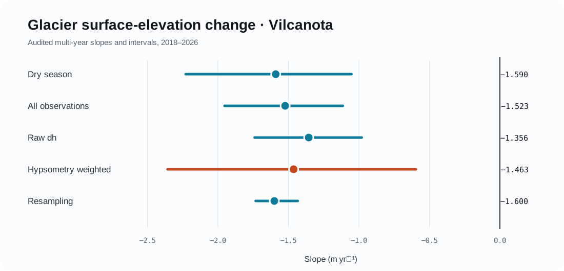
| Estimator | Slope (m yr⁻¹) | Uncertainty | Use |
|---|---|---|---|
| Dry-season h′ | −1.590 | 95% CI: −2.229 to −1.053 | Primary product |
| All-observation h′ | −1.523 | 95% CI: −1.953 to −1.114 | Temporal sensitivity |
| Raw dh | −1.356 | 95% CI: −1.740 to −0.980 | Without hypsometric correction |
| Hypsometry weighted | −1.463 | 95% CI: −2.357 to −0.596 | Regional result |
| Hypsometric resampling | −1.600 | P5–P95: −1.732 to −1.434 | 50 iterations |
Hydrological years
The diagnostic cumulative change relative to HY2020 reaches −6.90 m for the dry season and −8.10 m for all observations through HY2025. It is not a complete geodetic mass-balance estimate.
Defensible inference
A robust multi-year surface lowering close to 1.5 m yr⁻¹ is present, with stronger loss at lower and middle-lower elevations. Stable-terrain masking and residual NMAD remain open uncertainty components.